
Journal: Pages 57-58
My
two days on Mt Ruapehu were completely rained out. Not that it was a setback at
all: Leaving the volcano afforded me a day along the Thermal Explorer's Highway
to Rotorua, and gave me a good reason to return in the future.
After breakfast, I drove on uneventfully southward to rejoin Highway 1 towards the national capital. En route, I wished I could make frequent stops to photograph the "lumpy" volcanic green hills, some terraced and many chock full of sheep, which from the distance looked like maggots on the verdant landscape.
I
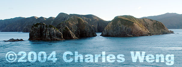
made it to the ferry docks just under two hours before the next southbound
departure, which I booked immediately at the lowest possible price. By cruising
the picturesque Queen Charlotte Sound towards Picton (a scenic gift to those
traveling between the North and South Islands) at dusk, I maintained a streak of
maritime journeys for every trip I've taken since 1998, counting the Inside
Passage of British Columbia, the ferries of the Norwegian fjords and the Swedish
lakes, the Grand Canal waterbus of Venice, the crossing of Lake Constance (Bodensee)
between Friederichshaven, Germany and Romanshorn, Switzerland, the voyage to
Kangaroo Island in Southern Australia and the tour of Milford Sound in the
Fjordland of South Island.
I
was getting tired of pies, fish and chips (one order aboard the ferry and
another upon finding my affordable motel in Picton), which unfortunately were
the only hot food I could get late and on the cheap. The bag of tiny mandarin
oranges I bought two days ago were absolutely delicious; regrettably I may not
be able to finish them by the time I get back to Auckland.
Monday
31 May 2004
Itinerary:
Picton - Queen Charlotte Drive - Hwy 6 to Nelson, Richmond and back
Photo
Stops of the Marlborough Sounds:
Overlook
of Picton Harbor
Walk
to beach at Governor Bay, a small extension of the Grove Arm, itself extended
from the Queen Charlotte Sound
The
people-friendly ducks of the Momorangi Bay Marina (I felt bad about not feeding
them, as apparently many others did)
Walk
up to the geographical marker at Cullen Point, overlooking Mahakipawa Arm to the
east and the fishing resort of Havelock to the west
Pelorus
River and the Pelorus Bridge
Beach
at Nelson, looking towards Tasman Bay